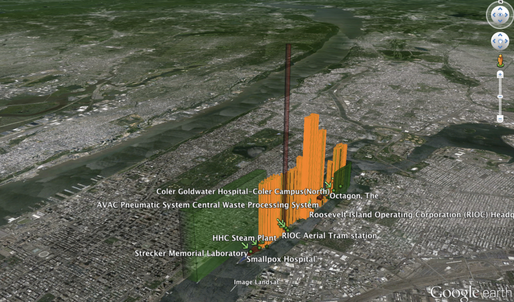
3D visualization with electricity consumption (orange), and energy generation options (potential CHP plant and solar in red, tidal energy in green). The height of the 3d extrusion represents the total amount of kilowatt hours of electricity consumed and produced.
Download this KMZ file to view the above visualization in Google Earth. Make use of the tilt and zoom functions to get an optimal perspective.
The building footprint GIS layer used in the above visualization was obtained from New York City DOITT. The building footprints were then combined with building data from RIOC and electricity consumption data from a 2008 ERS/NYSERDA study conducted to evaluate CHP options for the Roosevelt Island steam plant. Four energy generation option polygons were added for the steam plant and Motorgate garage and tidal energy project locations. The ArcMap layer was then exported as KML using the Xtools Pro plugin.
Background
In the summer of 2010 I managed a research project titled “Roosevelt Island: Vital Design,” co-funded by an EU grant through the Cradle to Cradle Islands project co-organized by the Province of Fryslân. The project was a gift to the Roosevelt Island Operating Corporation (RIOC) and was meant to encourage sustainable development initiatives on the island and international information exchange. With a fantastic interdisciplinary research team including Juliette Spertus, who started a study of the island’s pneumatic tube waste removal system with her “Fast Trash” exhibit, we gathered information about the management of materials, water and energy on the island. I was responsible for evaluating energy-related issues and was able to use the project as a case study for a Geographic Information Systems for Sustainable Development class that was part of my major.
Project Wiki
In order to facilitate collaboration between the various people and organizations involved in the project — spanning a variety of disciplines, timezones, cultures, and generations — I set up a Wikispaces page, which was gifted to the RIOC when the project was completed.
GIS Project
Roosevelt Island was supposed to be the “island of the future.” Hopes were high for the island to serve as a microcosm example of urban life improved by technology (1973 New York Times article about Roosevelt Island). Unfortunately, only some of the goals of the island’s designer visionaries were realized. The Roosevelt Island Operating Corporation (RIOC) — the island was leased to the New York State Urban Development Corporation for 99 years in 1969 — is struggling to gather the funding and organization needed for capital improvements of the island’s infrastructure. I was asked by the Province of Fryslân, which funded the project through an EU grant, to be part of a team of investigators and given the task to analyze energy supply and consumption on the island.

Data in this map is from a 2008 study commissioned by the Roosevelt Island Operating Corporation, sponsored by NYSERDA and executed by ERS. ERS collected electricity bills from Roosevelt Island Residential Apartment Buildings and the Roosevelt Island Operating Corporation (RIOC) in order to assess the feasibility of a Combined Heat and Power Plant retrofit of the Island’s existing Steam Plant, built in 1936.
